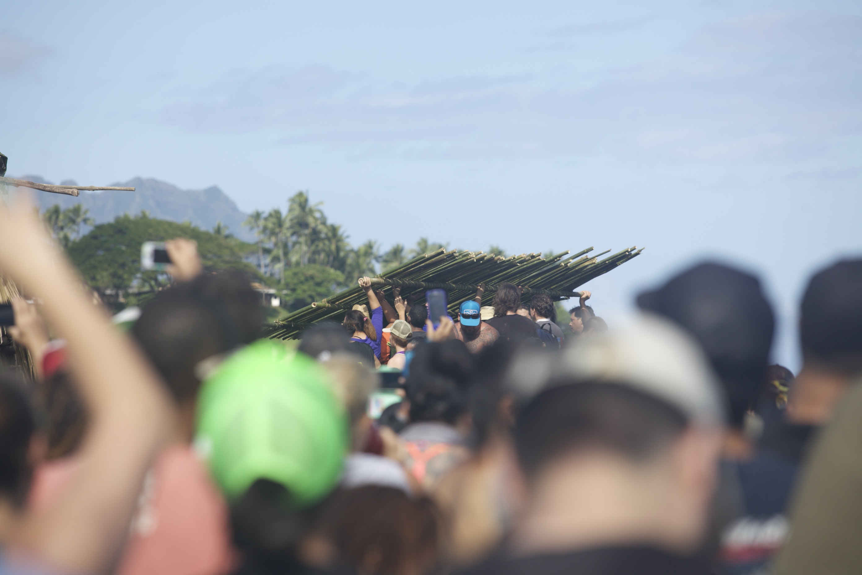
My gloved hands claw at the 6-foot-high hill of coral and toss small chunks into the waiting mouth of a white sack woven of marine-grade fiberglass. Around me, two dozen students are also grabbing and bagging. The University of Hawai‘i Natural Resources and Environmental Management (UH-NREM) class is studying community-based efforts across the islands, hands on.
We’re offering our sweat equity to help maintain a prehistoric loko kuapā (walled fishpond) encircling the edge of Kāne‘ohe Bay flanking He‘eia State Park. The bags of coral will be used to weigh down the mesh lining the edges of the pond’s inner pens, so that it lies flush and gap-free against the substrate, preventing small i‘a (fish) from slipping out.
A no-nonsense voice cuts through the thuds and chatter: “Keep ‘um softball size, and only fill the bags halfway or going be heavy to carry.” Our coach is a tanned, lean woman wearing a dirt-enhanced rash guard and board shorts, her ponytail tucked into a trucker’s cap. Hi‘ilei Kawelo, a biologist and avid surfer, is co-founder and executive director of Paepae o He‘eia, the nonprofit that is restoring the pond.
Kawelo sets our goal at 100 bags; these, plus 50 bagged earlier by other volunteers, will properly secure the pens. We scurry, grab, toss, tie. Not the stare-at-a-screen solo work I am used to, the shared task feels gratifyingly zen. The bags multiply fast and, sooner than expected, we’re done.
Kawelo then declares that all the bags, each weighing 20-plus pounds, must be moved 200 feet and stacked by the pond’s dock, ready for the repair crew to grab and go. I pity my back, dreading the long schlep.
“OK, gang, let’s make a halihali line,” she says and gestures downslope. Halihali, in Hawaiian, means to transport, and community members customarily formed lines to efficiently move a large number of bulky or heavy items over an extended distance. In this way, we would pass the bags until they reached the shore. We offset ourselves half an arm’s length apart, facing one another so as to receive the bag from the person on one side and heave it cross-body to the other.
My first transfers are awkward. Like a crab in a relay race, I scoot over to grab a bag from one person, shuffle back to pass it to the next, and try not to drop it on anyone’s foot en route. Observing this, Kawelo advises that each of us should hold our stance, and swivel in one motion from the waist. The human chain tightens as we shrink the space between us. Momentum builds, and the bags seem to lighten, buoyed in the fluid rhythm of many working as one.
This is how He‘eia Fishpond was first built 800 years ago.
Aina Momona
The pond walls trace a slim, dark line along the horizon, erased in one gap where 1965 floodwaters gushing off the land had rammed through. Built on the fringing reef extending from the shoreline into Kāne‘ohe Bay, the kuapā measures 1.3 miles long, possibly the longest in the Hawaiian archipelago.
I marvel at the commitment it took to build this. A halihali line of thousands of Native Hawaiians labored hand by hand, stone by stone, for two or three years to complete the massive wall. Countless tons of coral and rock were hauled from the bay and surrounding lands, re-birthed as a living icebox through the community’s will to sustain itself.
In the mid-19th century, the Hawaiian sage and historian Samuel Kamakau wrote that those who had fishponds on their lands “loved the lands where they dwelt … Fishponds were things that beautified the land, and a land with many fishponds was called ‘fat.’”
Formerly known as an ʻāina momona, or a land “fat with food, Oʻahu had extensive lo‘i kalo (taro) systems in each of its 81 ahupuaʻa, and by far the most loko i‘a (fishponds) of any island. An early 1900s survey showed at least 600 loko i‘a on O‘ahu. Most were filled in, overgrown and abandoned over time, and the practice of pond aquaculture ceased. He‘eia Fishpond is one of only six active fishponds left in Kāne‘ohe Bay, once ringed with dozens of abundant ponds.
He‘eia was a primary population center for ancient Hawaiians living in Windward O‘ahu. Part of the Ko‘olaupoko moku (district), the ahupua‘a starts at the summit of the south-westward Ko‘olau, a vital watershed, and includes two steep-cliffed valleys, Ha‘ikū and ‘Ioleka‘a. The valleys are ribboned with five streams that merge into He‘eia Stream beginning near Pu‘ukeahiakahoe and draining into the marshy flatlands and brackish estuary fringing Kāne‘ohe Bay. Finally, the ahupua‘a leaps across the bay to include much of its reefs and fisheries, as well as part of Mōkapu peninsula, now used as Kāne‘ohe Marine Corps Base.
Comprising 2,500 acres, the He‘eia ahupua‘a contained the wide range of land and ocean resources needed to support a self-sufficient economy. Taro was grown in verdant, terraced lo‘i, while algae, mullet and moi thrived in fishponds fed by the stream. Fishing communities shared their bounty with people farther from the shore who, in turn, provided food and materials fruitful in their areas.
A mālama ‘āina renaissance is engaging thousands of community stakeholders—residents, schools, government agencies and landowners—to restore He‘eia’s former glory. At the forefront are three Hawaiian-led organizations caring for different parts of the ahupua‘a: Papahana Kuaola in the uplands; Kākoʻo ʻŌiwi in the wetlands; and Paepae o He‘eia at the shore.
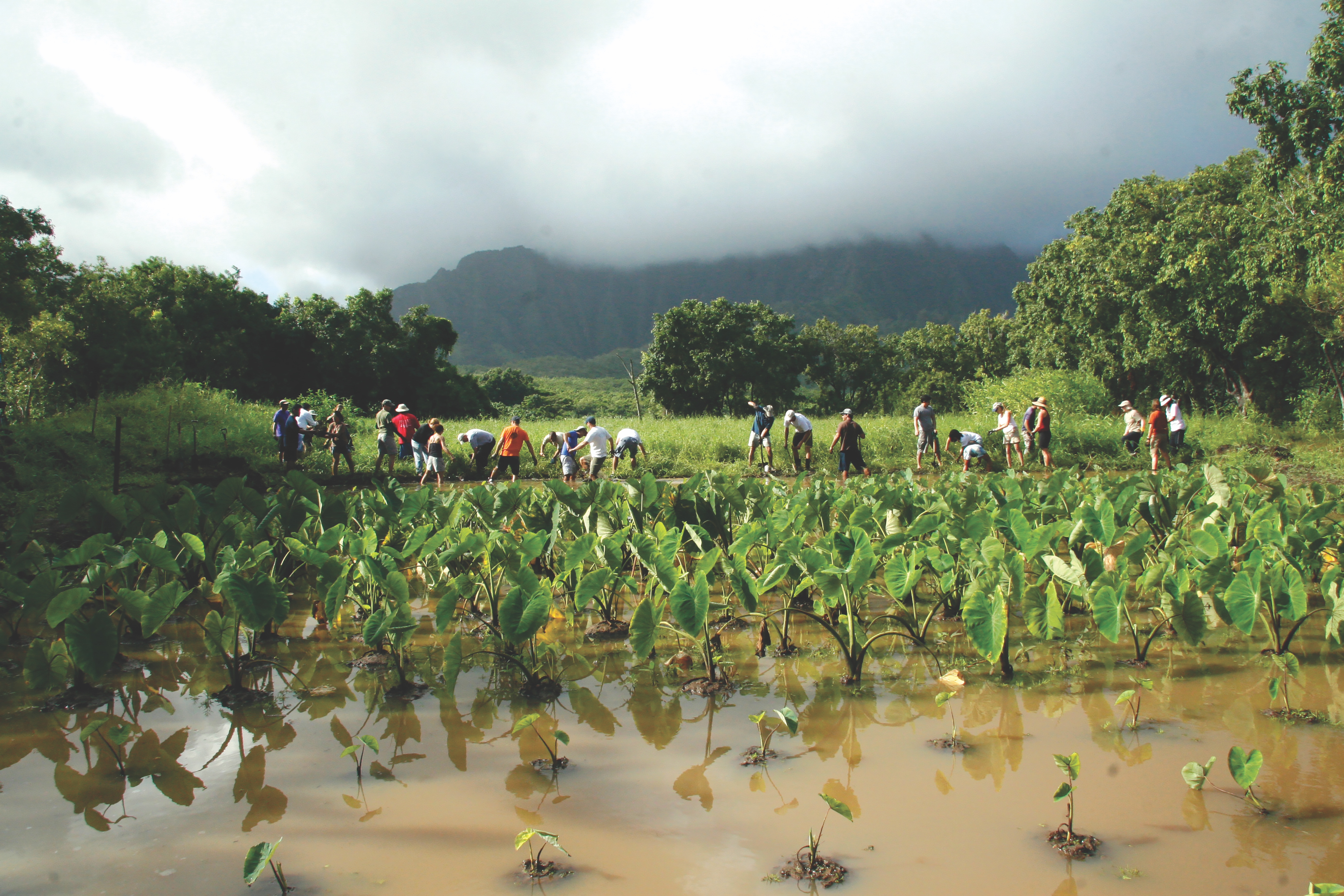 Volunteers from the Nature Conservancy mahi - labor - at a taro patch
Icebox For All
“He‘eia Fishpond is here to provide food for our community—fish,” Kawelo says. “It is a resource left by our kūpuna (ancestors) to feed our people.” At its peak production in the 1800s, the 88-acre pond was able to sustain a population of more than 5,000 people, roughly the number of residents living in the He‘eia ahupuaʻa today.
With fish as the main protein in their diet, Hawaiians invented fishponds with remarkable ingenuity to assure a perennial supply. Hawaiian fishponds are unique forms of aquaculture found nowhere else in the world. While techniques of trapping or herding adult fish in tidal areas are used elsewhere, Hawaiian fishponds, especially kuapā, were technologically advanced in efficiently cultivating pua, or baby fish, to maturity.
Hawaiians observed how tides affected the behavior of marine species, and this knowledge shaped their understanding of the environment and species that served as their food. Working with the natural cycles of moon and tides, Hawaiians regulated the balance of salt and fresh water within the pond, creating a fertile ecosystem for breeding fish.
Mākāhā (sluice gates), built into the kuapā where currents occurred, let pua swim in and graze on limu (seaweed) grown in the pond, while keeping predators out. ‘Ama‘ama (mullet), moi (threadfin) and ‘awa (milkfish), growing too big to swim out through the gates, would be corralled. Fishpond technology moved Hawaiians beyond the mere harvesting of natural fish populations into the realm of fish cultivation.
Kawelo comes from a long line of fishermen that goes back many generations, all rooted in this wahi hānau, or place of her birth. But invasive overgrowth, creeping suburbia and decades of disuse hid the pond from view. “Growing up, I’d drive down this road, and our family would party at the park,” she says, “but I never knew it was here.”
Kawelo first discovered the pond as a UH student, brought by her close friend Mahina Paishon, who was among a loose group of volunteers working to rescue the pond. Kawelo’s first sight of the pond in 1998 stirred awe and dismay: “It was all mangrove and mosquitoes everywhere. You couldn’t see the horizon, the ocean; just trees, weeds. ‘Somewhere beneath all that mangrove, there’s a fishpond wall?’”
Post-grad, the biologist worked at the Oceanic Institute aquaculture facility at Makapu‘u, and volunteered at the pond for years. Then, in 2001, she, Paishon and six other young Native Hawaiians founded Paepae o He‘eia to reclaim the crumbling treasure. Securing a long-term lease for the pond lands from the landowner, Kamehameha Schools, the group first worked out of a Matson container and rusty quonset hut overlooking the pond clogged with mangrove, sediment and invasive limu.
“It was very daunting; still is,” Kawelo says. But the challenge offers her a 360-degree dose of life: “Here, you’re a teacher, you’re an anthropologist, archaeologist, an engineer, a chemist, zoologist, marine biologist, or ‘limu-ologist.’ Every day you could be all of those things—and I like that.”
A dedicated staff of 10 now lead thousands of students, scientists and volunteers each year in educational, research and stewardship activities. A meeting hall, open-air patio and traditional hale (hall) host classes, work activities and community gatherings.
Kawelo leads us on a walk along the restored kuapā facing Mōkapu peninsula, up to the edge of the puka (hole) torn by the flood. Originally 200 feet wide, restoration has narrowed the gap to 80 feet. Until it’s closed, the pond can’t serve its function. Waves wash through the gap; fish swim in and out. “People come in the big puka and lay net. So it’s no longer a place of aquaculture, but a place of fishing,” Kawelo explains.
But its foundations, its niho (teeth), remain strong and firm. These oldest and largest rocks form the backbone of a structure that has survived 800 years of surging surf, and disasters both natural and man-made.
Regrowing Hoi
Just across the road from the pond, and through a cattle gate, lie He‘eia’s sprawling wetlands that locals call the Meadowlands. Traditionally known as Hoi, these lands once served as the food basket for the ahupua‘a—and for all of O‘ahu during times of drought.
To my eye, these lush 405 acres of marshlands look pristine. But marine biologist Kanekoa Kukea-Shultz sees a deteriorated native landscape. As the purifying lungs of He‘eia’s estuarine system, these wetlands are made to slow water flow, absorb and control flooding, and filter muddy water as it flows seaward.
A heavy rain in the Ko‘olau will flow through the valleys and streams, over impermeable built surfaces, across the marsh, and flush through He‘eia Fishpond on its way to Kāneʻohe Bay. Here, the nutrients and sediment will nourish acres of invasive algae and choke the bay’s coral reefs—the base of the chain of life for these once-teeming fisheries.
“We’re trying to hold as much sediment and water as we can here,” says Kukea-Shultz, who is also the executive director of Kākoʻo ʻŌiwi, which seeks to stabilize and heal these wetlands. He serves as the Kāneʻohe Bay marine coordinator for the Nature Conservancy of Hawai‘i, and has worked with the Kaho‘olawe Island Reserve Commission, gaining expertise in ecosystem recovery. Kukea-Shultz is also one of the co-founders of Paepae o He‘eia, a stone’s throw across the road.
The community-driven Kākoʻo ʻŌiwi project grew out of, and dovetails with, the conservancy’s reef protection work removing invasive limu and outplanting wana (sea urchins) to curb its growth on Kāneʻohe reefs, which lack a herbivore fish community to naturally mow them.
Kukea-Shultz says the Hawaiians’ food production system at Hoi enhanced the entire estuarine ecosystem. “Lo’i and fishponds existed up here, and held onto sediment during flood events. That’s how the idea of rebuilding fishponds and taro patches came to be.”
The Ko‘olaupoko Hawaiian Civic Club launched Kākoʻo ʻŌiwi in 2009, and the nonprofit entered into a 38-year lease with Hawai‘i Community Development Authority (HCDA) in 2010 to implement Māhuahua ʻAi o Hoi (Replanting the Fruit of Hoi), a project to restore the fallow land into a working agricultural landscape. The project focuses on increasing food security and biological resiliency, research and education, and opportunities for cultural and community use.
A Kamehameha Schools graduate, Kukea-Shultz says a 1928 photograph of Hoi resplendent with kalo and native crops is his master plan. “And my mission is to fulfill what the kūpuna remember and want to see again,” he says. “Our board is made up of kūpuna who helped to fight for this land in the ‘70s. Their vision is for this land to be brought back to life, and to feed the community once again.”
One kupuna yearns for the day when “koloa, ‘alae ‘ula, and ae‘o have returned and the splashing of ‘ama‘ama sounds like rain falling on He‘eia Stream. Clean, clear water feeds the fishpond and native limu and other marine life are once again abundant.”
Heʻeia kūpuna Aunty Alice Hewett recalls how, as a young child, she delivered poi in hand-sewn bags from her ʻohana’s Heʻeia poi shop to families and local markets. Today, Kākoʻo ʻŌiwi is continuing the tradition of making poi milled in He‘eia more available and accessible to families and businesses in Kāneʻohe.
The gargantuan size of the property is its greatest asset—and its biggest challenge. Restoration work is labor-intensive, and lacks the steady funding support that Kamehameha provides the fishpond project or Papahana Kuaola up the mountain. Kākoʻo ʻŌiwi looks toward revenue generation and grants to cover conservation costs. Local chef Lindsey Ozawa, its marketing director, is forging alliances with other chefs and food industry experts to leverage the growing interest in pesticide-free produce.
Growing kalo will also restore a traditional food-based economy in Windward O‘ahu, Kukea-Shultz says. “If we get this wetland up and running, you’re looking at least 50 kalo farmers alone—that’s a huge industry! So that’s the hope and the idea.”
To date, 4 acres of kalo and 20 other food crops have been planted. “We’re also ‘growing’ limu,” jokes Kukea-Shultz. Invasive algae pulled from the bay and pond are brought here and turned into rich compost. Farm staff battle daily with fast-growing invasive grasses and mangrove, introduced by early sugar planters to mitigate the runoff from intensive agriculture. Migrating downstream, mangrove reduced wetland habitat for native species and clogged the stream channel and ponds where its root systems undermined the structure of pond walls.
Kalo is key to restoration. The long-term goal is to return 200 acres of native wetlands to kalo production, with the lo‘i banks built higher than usual to help the ponds retain storm flows and to trap sediment. In addition to growing food, the biologist says, “The lo‘i will mitigate flood events and save our reefs. Taro patches and irrigation going through ‘auwai (irrigation ditches) will oxygenate the water coming down the valley. From an ecological standpoint, there’s a lot of ecosystem services tied into actual farming.” Ecosystem services are the important benefits provided by ecosystems to humans. Currently, the marsh sucks up all the oxygen flowing seaward into He‘eia pond.
Freshwater ponds are also being created at Hoi. As part of He‘eia’s estuary system, baby fry migrate from the ocean to He‘eia Fishpond and up the stream into Hoi, Kukea-Shultz explains. Partnering with the National Oceanic and Atmospheric Administration (NOAA), Kākoʻo ʻŌiwi built a tank to acclimate ahole‘hole and mullet fry to a freshwater pond at Hoi. But the oxygen level was so low, few of the fish survived.
While touring the farm with two private chefs interested in doing business with Kākoʻo ʻŌiwi, we see several young people crouched next to a pond. They are hooking up photovoltaic panels to what looks like a giant aquarium pump. “The solar aerator helps to increase oxygen, so we can again grow fish up here,” says Kukea-Shultz. When the aerator is plunked into the pond and bubbles rise to the surface, the crew hoots with joy.
Kākoʻo ʻŌiwi’s tiny but mighty team is made up of Lindsey Ozawa, Kamuela Yim and Nick Reppun, who handle marketing, education outreach and farm operations—respectively, and often together.
Nick Reppun has mud under the nails and passion for the task of nurturing both land and community health. Sustainably managed farms “serve as our primary healthcare providers,” the farm manager says, “so growing produce for the local market has a direct impact on the health of the community. The more people we can involve in food production the better, and ideally the people are consuming what they help us to produce.”
Wai Ola
Beyond the fishpond’s mirrored waters and the Hoi marshlands, He‘eia ahupua‘a is a mix of rural and urban, and of the sacred and secular. Next to Kāne‘ohe town, its crazy quilt of houses and malls overlays green velvet valleys, and three concrete highways snake up into the fluted cliffs of the Ko‘olau—the sacred home of wai ola, the living waters.
For Hawaiians, water was cherished as a gift from the gods. As it flowed from the upland forest, down through the ahupua‘a, it passed from the wao ākua, the realm of the gods, to the wao kanaka, the realm of man, where it sustained farming, fishing and other human uses. So precious was wai that the Hawaiian word for wealth is waiwai: water in great abundance.
Hahai nō ka ua i ka ulu lāʻau (Rain always follows the forest). The Hawaiian proverb distills what Western science confirms: Clouds form around the tops of forested mountains, our primary watersheds, releasing rain that recharges our underground aquifers and provides clean water for our streams.
In Waipao, in He‘eia mauka, everything is cool, green, brown and/or wet: clouds, mist, mountain, trees, streams, mud and lo‘i kalo. Fed by the heavy rains, over a dozen waterfalls pour down sheer cliffs. An eternal sense of scale pervades.
I’m muddy and drenched along with 70 O‘ahu high school students visiting Papahana Kuaola, the nonprofit that is co-stewarding this place. The Kamehameha Scholars are here to explore ‘āina-based careers—and the ‘āina itself. Hui Kū Maoli Ola, a social enterprise that is re-establishing native vegetation across the islands, is co-located here with its educational arm, Papahana Kualoa. The 63-acre parcel is leased from Kamehameha Schools, which provides partial funding to help support culture-based education at the site.
“I’m super serious about our mission: ‘āina restoration, economic sustainability and traditional Hawaiian knowledge that honors the connection between ‘āina, ākua and kanaka,” says Kīhei Nahale-a, director of Papahana Kuaola’s curriculum and program development initiative.
The two groups seek to transform land back to ‘āina—that which feeds—and join in educational, advocacy and forest restoration projects to protect He‘eia’s watershed and streams and eradicate invasive plants that promote runoff.
An idyllic refuge of native gardens, ancient pōhaku (rock) terraces, lo‘i kalo, and clear, rushing stream, the area could be Hawai‘i as it was a millennia ago. But, for decades, this land was used as a dump. “Trucks would come and dump their trash. The whole hill was all construction rubbish: concrete, rebar,” Nahale-a says. Since then, invasive vegetation and trees have been cleared, and over 3 acres of loʻi kalo, as well as native stands of forest, have been re-established. Native bird trills signal the return of native species to their uplands habitat.
Nahale-a guides us across He‘eia Stream, which runs through the site. He directs the teens to form a halihali line to move 10-foot pipes over to help build a new lo‘i. The teens are about to hunker down when high-pitched screams erupt. A pipe had been picked up, and two huge rats had skittered out.
The hefty man cracks up. With his buckaloose beard a wild web of raindrops, Nahale-a is a talented and respected musician, composer, cultural practitioner and youth mentor impassioned about his culture. “I tell the kids, knowledge is power. Go get a degree. But if knowledge is power, wisdom is mana.” Mana is the spiritual power connecting all living things, animate and inanimate.
Nahale-a takes the students to wash off in the stream, then guides us to a spring with water so clean you can drink it. He feels a deep kuleana, or responsibility, to keep it so: “What if one day you can’t drink the water anymore, it got all junk on my watch? That’s on me, because I’m the one who didn’t protect the sanctity and purity of that.
“It’s all about the water and the forest. We need to keep the water clean and flowing, to get the purest water down to the fishpond,” he says. “There’s a legacy to lose here. It’s the spirituality of the place, the purity of the water, and the healing that this land brings to people. We really have to start healing our land, one ahupua‘a at a time.”
He quotes the Hawaiian proverb: “He ali‘i nō ka ‘āina, ke kauwā wale ke kanaka. The land is the chief; man is its servant.”
Kuleana
Two women stroll from the Waipao forest, chatting and laughing softly. Nani Kauka and Kamanu Bicoy are “regulars” at Papahana Kuaola who arrived to help as usual, undeterred by the heavy rain. As they towel off by their car, about to leave, I ask the two Kailua residents why they come. Smiling, they shrug off the term “volunteers.” “In our culture, that’s the way it’s supposed to be; everybody works together. There’s jobs for keiki and kūpuna; everybody gets in and helps out,” Kauka says. It is a kuleana-based system, one in which everyone has a responsibility to take care of the ahupua‘a.
The retirees also help out at Paepae o He‘eia and Kākoʻo ʻŌiwi. “We love working with all these guys,” Bicoy smiles. “And goodness, we learn so much!” The three partner sites stagger their community work days to coordinate broad involvement.
Today, as in days of old, it takes a village to sustain the health of an ahupua‘a. “Because restoration work is never over,” Nahale-a says. “You can open up lo‘i, but they grow quickly. So how can you keep them open? One answer, right? Community.”
In 2007, the Ko‘olaupoko Hawaiian Civic Club and the Department of Transportation teamed up to launch the Ko‘olaupoko Ahupua‘a Boundary Marker Project. “The people who live and work in an ahupua‘a are responsible for caring for the resources in it, natural and cultural,” says Māhealani Cypher, the civic club’s then-president who spearheaded the project. Cypher is a longtime community advocate who was born and raised in He‘eia. Because people often don’t know which ahupua‘a they live in, she says the club created the project “to connect people with the ‘āina in which they live, and with their kuleana.”
Today, signs marking traditional boundaries can be seen throughout the Ko‘olaupoko district, from Kualoa to Kailua to Waimānalo, as well as other O‘ahu ahupua‘a, including Waikīkī. The project has even gone statewide to the other islands as well.
The civic club also engages community members, especially Native Hawaiians, in other projects caring for the natural, historic and cultural resources of He‘eia, and other ahupua‘a of Ko‘olaupoko. Every month the club leads a cultural access into Ha‘ikū Valley to remove alien vegetation and litter, and to educate community members about the significance of this wahi kapu, this sacred place.
Kupa‘āina
Warring worldviews and values have drastically reshaped He‘eia since Western contact. But pivotal grassroots victories in He‘eia and neighboring ahupua‘a led by kupa‘āina, citizens of the land, paved the way—and preserved the possibility—for the ahupua‘a restoration taking place today.
Abner Paki, the konohiki and high chief of the ahupua‘a of He‘eia, was the first recorded owner of all the lands of He‘eia at the time of the Great Māhele of 1848. His daughter, Princess Bernice Pauahi Bishop, great-granddaughter of Kamehameha the Great, inherited these and other lands. Witnessing the disease and poverty that devastated the Hawaiian population, she set up a bequest that created schools to educate and empower Hawaiian children, supported by her lands, upon her death in 1884.
The Bishop Estate, now Kamehameha Schools, is the largest private landowner in Hawai‘i, with nearly 350,000 acres of agricultural and conservation lands on five islands.
With the privatization of land, thousands of Hawaiians and their role in the kuleana-based economy were displaced off Windward lands. Kalo farming in He‘eia’s expansive marshlands gave way to sugar, rice, pineapple and cattle. Large-scale crop cultivation practices led to widespread soil erosion. But, by far, the bulk of soil runoff, sewage and pollution came with increasing urbanization of these rural lands after World War II.
In post-statehood Hawai‘i, development boomed, fueled by a growing demand for housing. The Pali and Likelike highways, built in the 1960s, linked Kāne‘ohe to Honolulu, bringing increased urban sprawl to Windward O‘ahu. A third roadway, H-3, was later built as well, despite three decades of protest.
Since the 1960s, these sleepy communities had been slated to become O‘ahu’s second city. Rural landscapes would morph into a new Hawai‘i Kai on the Windward side. But residents fought the battle of their lives to stave off eviction from their small farms.
Learning of plans to build a marina, condos and 7,000 million-dollar homes in Waiāhole and Waikāne valleys, residents united in a fierce populist uprising that galvanized solidarity across the islands. “There are two kinds of bombs: those that blow up, and community,” says John Reppun, emeritus executive director at the Kualoa-He‘eia Ecumenical Youth (KEY) Project, which was a hub of grassroots activism in 1968.
The snow-haired, smooth-faced Reppun is a third-generation kupa‘āina; his grandfather and father, both medical doctors, actively engaged in Windward civic affairs and social justice issues. Reppun and his brothers, Charlie (father of Nick Reppun) and Paul, had gone to college on the continent, but came home to farm and to dive into community advocacy: “We were fighting against the plans downtown Honolulu had for our community,” he says.
In 1975, Hawaiian Electric Co. (HECO) moved to evict 21 He‘eia Kea residents, mostly Hawaiians and small farmers, from land it acquired through a lease-purchase agreement with Bishop Estate to build a new power plant. Leialoha “Rocky” Kaluhiwa, one of the residents to be evicted, says, “My family has been in the ahupua‘a for over 200 years. My Grand-Uncle Ulysses Jones was the last konohiki for water in the ahupua‘a of He‘eia, and many of our families are buried in the uplands.”
HECO first explored nuclear power to feed the enormous energy needs that the planned development of the Windward coast would require. “They said that because the valley was bowl shaped, it wouldn’t cause any pollution; it wouldn’t go over the mountain, or into the ocean.” Kaluhiwa’s voice rises, “But we found out they needed ocean water for coolant, and our ocean was zoned AA waters—top waters. You can’t put a plant like that to pollute it! Harmless? Few years later, we saw the mainland had Three Mile Island (a partial reactor meltdown), and then Japan (Fukushima). It would have been a major disaster for Kāne‘ohe Bay!”
Developers also planned to dredge the Meadowlands and He‘eia Fishpond, and replace them with resorts, a deep draft harbor, oil refineries, a 625-berth marina, townhouses, high-rise condos and a luxury golf course.
Tūtū Kawelo, Hi‘ilei Kawelo’s grandmother, took part in the Windward struggles. Her weary resolve and strength are captured in Kū‘e: Thirty Years of Land Struggles in Hawai‘i, a book co-authored by He‘eia resident Haunani-Kay Trask, the Native Hawaiian leader, poet and educator, and photojournalist Ed Greevy, documenting the Waiāhole-Waikāne and He‘eia struggles.
Trask and Reppun were part of the He‘eia organizing “combat team.” Against the odds, the Waiāhole-Waikāne community prevailed. In a historic move, the state paid the landowner $6 million in 1978 to establish an agricultural park. Farmers like the Reppuns now have 50-year ag leases at affordable rates. After that, the plan to develop the Windward coast was scrapped and developers turned their attention to former plantation lands on the Leeward side instead.
When the Waiāhole-Waikāne project died, so did the He‘eia plans. The trust traded 405 acres of wetlands to the Hawaii Community Development Authority for a quarter acre in Kaka‘ako.
Reppun reflects, “All that’s happening today would not have happened if not for those battles. We made enough noise to create enough support for the land exchange.”
Path to Pono
“I had a role in that sad history,” rues Neil Hannahs, director of Kamehameha Schools’ Land Assets Division. “Given our fiduciary duty, we were trying to advance the economic opportunities on our land.”
He rewinds back two centuries to the dilemma facing the ali‘i, the Hawaiian royalty. “With depopulation of Hawaiians, our old economy didn’t work.” Instead, the influx of foreigners “offered an export moment for us. We would take our lands, take the iliahi (sandalwood) from the land and trade it, put cattle on it. In the new market economy, we seized the opportunity, or we succumbed to the pressures,” Hannahs explains frankly. “And that altered how we managed. We commodified resources on the land, as well as the land itself.”
Bishop Estate aggressively leveraged its land assets for maximum profits to support Kamehameha Schools’ educational mission. “We thought we were doing the right thing. And in the context of time, given the dominant values of a world in which you’re told this is the thing to do, or highest and best use, you kinda get on that wagon,” says Hannahs, then in charge of developing the trust’s Kaka‘ako makai lands.
He recalls the He‘eia-Kaka‘ako land swap: “We gave them title to land that wasn’t being used, they gave us title to a piece of property in Kaka‘ako adjacent to lands we wanted to develop, with credits and so forth that made the deal even.” But today, responsible for the ali‘i trust’s agricultural and conservation lands, Hannahs looks back “and I go, ‘Omigod, we just cut out the belly of the ahupua‘a.’”
In the late 1990s, the estate also sparred with Windward residents over water—again with profits versus ecosystem and community preservation at the crux.
Charlie and Paul Reppun were among a coalition of small family farmers, Native Hawaiians and community groups that contested the diversion of Windward waters to Leeward O‘ahu. The Windward partners pushed for water to be released back to Windward streams, to restore the streams and bay ecosystem and fisheries which rely on freshwater flowing into the ocean. But large-scale agricultural and development interests, including Kamehameha Schools, joined by the state, pushed to continue the flow of Windward water to Leeward lands to subsidize golf course irrigation, short-term corporate agriculture and housing development.
The landmark Hawai’i Supreme Court “Waiāhole Decision” in 2000 represented a dramatic paradigm shift in how water allocation decisions are made, weighing public-private water uses and rights, and upholding the public trust doctrine into the 21st century.
During the Waiāhole water case, the trust was embroiled in painful turmoil that led to a shift in the trust’s land policies as well. Hawaiian stakeholders demanded that Kamehameha Schools get out of the legal proceeding and become more pono, Hannahs says, or “to mālama the ‘āina, to achieve an optimal balance of economic, educational, cultural, environmental and community returns or benefits. People called us out and said, ‘You’ve followed this pathway to a very unsettling place. Our kūpuna left us a better map, follow the map.’”
In 2000, Kamehameha created a strategic plan that charted its new path, including supporting culture- and ‘āina-based educational programs statewide. The Waipā Foundation—growing kalo in an ahupuaʻa entirely owned by the trust in Hanalei, Kauaʻi—and Paepae o He‘eia are among many groups that have been nurtured by this effort over the years.
The trust has also supported KEY Project programs for at-risk Windward youth, the majority of whom are Hawaiian. Reppun lauds Kamehameha’s “whole organizational shift” as “wonderful poetic justice.”
“Every ahupua‘a has its challenges,” he says. “Communities have the right and responsibility to dream.”
Sea Change
Resiliency—the ability to recover from stresses, even trauma—is recognized as a critical factor that enables a natural ecosystem, or a person or community, to survive and thrive.
Hawaiians knew this well, Kawelo says: “Resilient people, resilient community, resilient land. We are direct reflections of the health of our ecosystem. People gotta get on the ‘āina and out there in the ocean every day. Because the more we can be in tune with what’s going on, the better prepared we’ll be.”
In 2012, He‘eia was named by NOAA as part of the Hawaiian Islands Sentinel Site Cooperative, recognized as one of the most valuable and unique ecological locations in the world. The site is one of five cooperatives in U.S. coastal regions where climate change impacts will be intensively studied. The Hawai‘i site will focus on coordinating watershed protection efforts to reduce flooding, runoff and erosion; balancing ecological health with cultural and economic needs; coastal inundation, sea level rise, erosion and coral resilience.
He‘eia is also poised to be designated a research-focused estuarine reserve. A draft management plan is now being developed for public review in 2016. If designated, the new He‘eia National Estuarine Research Reserve would become a “living laboratory” encompassing 880 acres owned by the state and Kamehameha Schools, including the Hoi wetlands, He‘eia Fishpond, He‘eia State Park, the mouth of He‘eia Stream and the Hawai’i Institute of Marine Biology at Moku o Loʻe (Coconut Island).
Estuaries, tidal reaches where sea and stream mingle and marine species spawn, are some of the most fertile ecosystems on Earth. Recognizing their importance as the ocean’s cradle of life, NOAA’s National Estuarine Research Reserve System protects more than 1.3 million acres of estuarine habitats for long-term research, monitoring, education and stewardship from Alaska to Florida.
“I think it’s great. It brings attention to the work we’re doing here, and hopefully the reserve can be another type of model for community-based coastal management,” says Kawelo.
He‘eia was selected not only because of its high ecological value but also because of the extensive cross-cultural partnerships and high level of collaboration so evident here. Both federal designations would likely allow the He‘eia community partners as well as researchers studying the area a chance to compete for federal capital improvement funds, cutting-edge research and ecological restoration money.
Says Mehana Vaughan, professor of the UH-NREM class, “The He‘eia effort is significant because we’re on O‘ahu, in the heart of our most developed island, in just a place of such essential beauty. It represents a growing ‘āina-based restoration movement that is not just restoring the ecology of a place, but it’s restoring people and community.”
The He‘eia efforts also reflect a larger grassroots movement confronting critical choices taking place across Hawaiʻi and globally. “It’s so important that we have places like this that remind us that we live on an island and our resources are finite,” Kawelo says.
Pani ka Puka (Closing the Gap)
While cleaning up his files, John Reppun found and gave Hi‘ilei Kawelo a 1970s bumper sticker that read, “Kūpa‘a He‘eia.” Kūpa‘a means firm, strong, to stand fast.
The three groups stewarding the pond, wetlands and upland area coordinate their efforts as “Hanohano He‘eia.” “It’s how we define ourselves as a unit, the three of us collectively, and what we’re trying to do. It means prestigious, verdant, majestic,” Kawelo explains. “It’s everything that we want for this place: to restore this ahupua‘a to abundance.”
About 8,000 volunteers pitch in at the pond each year. But Hanohano He‘eia and its partners collectively mobilize many times that number. Residents, community groups, schools, businesses, government agencies, scientists and other stakeholders lining up to tackle the monumental task of saving the ahupua‘a—and ourselves.
At the end of the day on the kuapā, we form a circle and each of us expresses thoughts of the day’s efforts. I say I am grateful to feel the mana of all the hands that put the coral rocks in the bags, for the mana alive in the rocks, and in the pond itself.
With human help, the pond is springing back to life. Kawelo points out native plants “returning on their own, naupaka, ‘akulikuli, ‘ahu‘awa, nehe,” to grace the edges of the restored wall.
“We already see certain natural rhythms returning; we see different types of native water birds coming back like ae‘o, ‘akeke‘e and kolea,” Kawelo says. “You see different schooling fish in there in the pond, and for the most part they stay.”
The halihali line extends through time. Like He‘eia streams flowing to the sea, kuleana runs in the veins of generations of konohiki and kupa‘āina caring for their home. In a lo‘i kalo, huli (the leaf stalk cut from the top of mature taro) from one harvest are replanted to seed the next. Niho stones grip and hold their place so the wall can survive to feed. The forest and stream run clear to the sea, and reefs are abundant with fish.
The western wall remains thickly infested with mangrove that is being eradicated methodically. The crew hacks away at least 400 feet of mangrove from the wall, then spends the rest of the year repairing the wall itself. It’s slow-going, back-breaking work, Kawelo says. “But little by little. My uncle says, ‘Easy, easy. Haste makes waste.’”
By July of 2015, the 80-foot gap in the wall will be closed. By year’s end, the group will also install a new mākāhā and a hale kia‘i, or guard house, over it. A campaign is underway to raise the funds and volunteer hours needed to fuel the last sprint toward a historic milestone: returning the pond to being a fully enclosed ecosystem—and able to fully function.
“Closing the puka is a really big deal!” Kawelo exclaims. “We want to see fish, we need to feed people. I want to see this fishpond work, to see with my own eyes what I’ve only heard thus far or read in books. I want to see a mākāhā function as they should, the way the kūpuna tell us; to see how fish behave when they’re in there.”
The pond technology is evolving to adapt to a changing world. The new mākāhā modifies the pond’s ancient design, adding to the six mākāhā built into the original structure. “If a flood took this section out in ’65 without the mākāhā, that’s why we’re installing one now,” Kawelo explains, “to relieve the pressure when the next one rolls around.” More intense floods are a given, with extreme weather expected to increase.
Those who gave the pond new life and breath are not just looking to the past, but also gazing squarely ahead.
“I really feel like there’s going to come a time where people will see and understand why these places were preserved,” Kawelo says. “Maybe someday people will look back and say like, ‘Mahalo to all those kūpuna who 50 years ago had the foresight to restore an 800-year old fishpond. ‘Cause look at us now—we get fish.’”